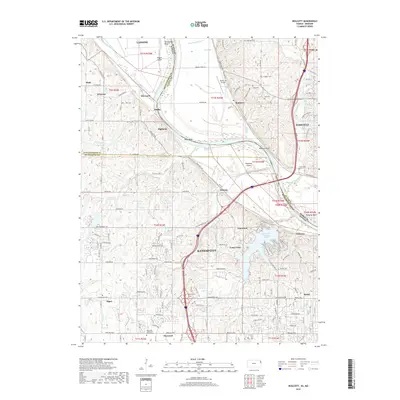
2018 Map of Wolcott
USGS Topo · Published 2018About this map
The Missouri River forms the central spine of this landscape, winding through a complex of bends and islands including Delaware Bend, Stigers Island, and Diamond Island. This 2018 survey captures the area at a point of suburban and industrial development where Kansas City meets the rural-industrial fringe. The topography is defined by the sharp transition from the river's floodplain to the dissected uplands of Wyandotte County Lake. Local genealogy and land history are well-represented by a high density of rural burial grounds, such as Dunagan Cem, Gray Cem, and Ellis Cem near the settlement of Waldron. Modern transport and community markers, such as Noah's Ark Airport and the Maywood Community Church Cem, appear alongside established settlements like Lansing and Parkville, illustrating the layered history of this river-valley corridor.
Find a feature on this map
112 named features on this map. Tap any name to fly to it.
Don’t see what you’re looking for? This feature index may not catch every label — zoom into the map to look around manually.
Map Details
Editions of this 2018 Wolcott Map
This is the sole edition of this map. No revisions or reprints were ever made.
Other maps of this area

1890 · Kansas City
USGS Topo · 1:125,000

1894 · Kansas City
USGS Topo · 1:125,000

1910 · Leavenworth
USGS Topo · 1:62,500

1914 · Smithville
USGS Topo · 1:62,500

1934 · Bonner Springs
USGS Topo · 1:48,000

1934 · Shawnee
USGS Topo · 1:24,000

1934 · Edwardsville
USGS Topo · 1:24,000

1934 · Wolcott
USGS Topo · 1:24,000

1940 · Bonner Springs
USGS Topo · 1:62,500
1943 · Shawnee
USGS Topo · 1:31,680