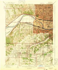
1943 Map of Shawnee
USGS Topo · Published 1943About this map
The Kansas River cuts a wide arc through the landscape of the early 1940s, separating the industrial corridors of Argentine and Turner from the upland residential growth in Wyandotte and Shawnee. This era shows a complex lattice of transit, where heavy rail lines like the Atchison Topeka and Santa Fe Railroad and the Union Pacific parallel the river, while the Missouri and Kansas Electric line suggests the commuter patterns of the day. Urban density is concentrated in the northeast corner at Kansas City, marked by civic landmarks such as the Court House and Soldiers and Sailors Memorial. Further south, the map documents a transition toward suburban developments and garden communities, including Crestline Gardens and Just Gardens, which began to fill the spaces between established hubs like Merriam and South Park.
Find a feature on this map
91 named features on this map. Tap any name to fly to it.
Don’t see what you’re looking for? This feature index may not catch every label — zoom into the map to look around manually.
Map Details
Editions of this 1943 Shawnee Map
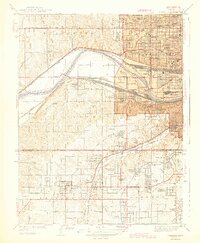
2 editions found
Other maps of this area

1887 · Olathe
USGS Topo · 1:125,000

1890 · Kansas City
USGS Topo · 1:125,000

1893 · Olathe
USGS Topo · 1:125,000

1894 · Kansas City
USGS Topo · 1:125,000

1934 · Bonner Springs
USGS Topo · 1:48,000

1934 · Grandview
USGS Topo · 1:24,000

1934 · Shawnee
USGS Topo · 1:24,000

1934 · Edwardsville
USGS Topo · 1:24,000

1934 · Wolcott
USGS Topo · 1:24,000

1935 · Olathe
USGS Topo · 1:24,000