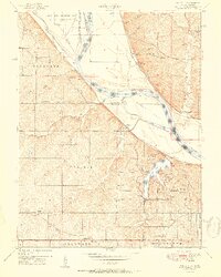
1951 Map of Wolcott
USGS Topo · Published 1951About this map
The Missouri River defines the landscape of this 1951 survey, carving deep bends and creating temporary landmasses like Stigers Island and Diamond Island along the Kansas-Missouri border. On the Kansas side, the Kansas State Penitentiary Farm and Camp No 2 occupy the northern bluffs, while the southern portion transitions into a network of small settlements and educational sites. Local history is anchored by rural landmarks such as White Church, Loma Vista, and Wolcott, alongside a dense concentration of one-room schoolhouses including Delaware School, Island Creek School, and Center Point School. The creation of Wyandotte County Lake and its surrounding Wyandotte County Park highlights the mid-century development of public recreational space amidst the traditional agricultural and Indian Reservation lands of Wyandotte County.
Find a feature on this map
61 named features on this map. Tap any name to fly to it.
Don’t see what you’re looking for? This feature index may not catch every label — zoom into the map to look around manually.
Map Details
Editions of this 1951 Wolcott Map
This is the sole edition of this map. No revisions or reprints were ever made.
Other maps of this area

1890 · Kansas City
USGS Topo · 1:125,000

1894 · Kansas City
USGS Topo · 1:125,000

1910 · Leavenworth
USGS Topo · 1:62,500

1914 · Smithville
USGS Topo · 1:62,500

1934 · Bonner Springs
USGS Topo · 1:48,000

1934 · Shawnee
USGS Topo · 1:24,000

1934 · Edwardsville
USGS Topo · 1:24,000

1934 · Wolcott
USGS Topo · 1:24,000

1940 · Bonner Springs
USGS Topo · 1:62,500
1943 · Shawnee
USGS Topo · 1:31,680