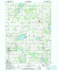
1992 Map of Wolcottville
USGS Topo · Published 1993About this map
The glacial landscape of the LaGrange and Noble County line is defined by a dense network of kettle lakes and marshy lowlands. Wolcottville and South Milford serve as the primary hubs of this rural corridor, connected by the Old RR Gr that hints at the earlier rail-dependent economy of the region. The map details a significant concentration of family and community landmarks, including the Woodland Cem and Brushy Chapel Cem, alongside smaller clusters like Woodruff and the lakeside development at Oakwood Terrace.
Find a feature on this map
59 named features on this map. Tap any name to fly to it.
Don’t see what you’re looking for? This feature index may not catch every label — zoom into the map to look around manually.
Map Details
Editions of this 1992 Wolcottville Map
This is the sole edition of this map. No revisions or reprints were ever made.
Other maps of this area

1940 · Orland
USGS Topo · 1:24,000

1941 · Orland
USGS Topo · 1:24,000

1942 · Stroh
USGS Topo · 1:24,000

1947 · Mongo
USGS Topo · 1:24,000

1947 · Lagrange
USGS Topo · 1:24,000

1947 · Wolcottville
USGS Topo · 1:24,000

1947 · Oliver Lake
USGS Topo · 1:24,000

1953 · Fort Wayne
USGS Topo · 1:250,000

1955 · Corunna
USGS Topo · 1:24,000

1955 · Kendallville
USGS Topo · 1:24,000