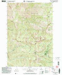
2004 Map of Wolf Fang Peak
USGS Topo · Published 2007About this map
Wolf Fang Peak and the surrounding wilderness of central Idaho are defined by high-elevation ridgelines and isolated mining prospects. This territory, split between the Payette National Forest and the Frank Church - River of No Return Wilderness, preserves a landscape where industry once touched the high peaks. Traces of extraction are evident at the McCrae Mine and the Independence Mine near Fawn Meadow, while the Goldman Cut marks the terrain near Windy Ridge. The map details a complex hydrology including the Middle Fork Elk Creek and Wolf Fang Creek, illustrating the steep drainage patterns typical of the Idaho and Valley County border. From the elevation of Mt Eldridge to the localized basin at Round Meadow, the survey documents the high-country infrastructure of the Krassel Ranger District.
Find a feature on this map
46 named features on this map. Tap any name to fly to it.
Don’t see what you’re looking for? This feature index may not catch every label — zoom into the map to look around manually.
Map Details
Editions of this 2004 Wolf Fang Peak Map
This is the sole edition of this map. No revisions or reprints were ever made.
Other maps of this area

1937 · Big Creek
USGS Topo · 1:48,000

1942 · Big Creek
USGS Topo · 1:62,500

1956 · Warren
USGS Topo · 1:62,500

1956 · Elk City
USGS Topo · 1:250,000

1960 · Elk City
USGS Topo · 1:250,000

1969 · Edwardsburg
USGS Topo · 1:24,000

1969 · Profile Gap
USGS Topo · 1:24,000

1969 · Parks Peak
USGS Topo · 1:24,000

1969 · Wolf Fang Peak
USGS Topo · 1:24,000

1969 · Big Creek
USGS Topo · 1:24,000