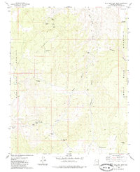
1979 Map of Wolf Hole Mtn West
USGS Topo · Published 1985About this map
Wolf Hole Mountain and Black Rock Mountain dominate this high-desert landscape in the late 1970s, where survival centers on a network of remote water sources. The map reveals the infrastructure of an arid cattle-ranching or wildlife-management region, with livestock and wildlife relying on features like Maple Reservoir, Low Mountain Reservoir, and numerous named springs such as Atkin Spring and Mustang Spring. The presence of the Wolf Hole Wildlife Res in the northeast corner underscores the area's role as a protected habitat. Travel across the difficult terrain is restricted to established Jeep Trails and Pack Trails that navigate through Maple Canyon and over Little Wolf Pass. This survey provides a record of the high-country hydrology and transit routes before more modern developments, preserving the names of local landmarks like Pocum Cove and Hodgets Canyon.
Find a feature on this map
29 named features on this map. Tap any name to fly to it.
Don’t see what you’re looking for? This feature index may not catch every label — zoom into the map to look around manually.
Map Details
Editions of this 1979 Wolf Hole Mtn West Map
2 editions found
Other maps of this area

1886 · Mt. Trumbull
USGS Topo · 1:250,000

1892 · Mt. Trumbull
USGS Topo · 1:250,000

1953 · Grand Canyon
USGS Topo · 1:250,000

1954 · Wolf Hole Mtn. NW
USGS Topo · 1:24,000

1954 · Wolf Hole Mtn. NE
USGS Topo · 1:24,000

1954 · Littlefield 3 NE
USGS Topo · 1:24,000

1954 · Littlefield
USGS Topo · 1:62,500

1954 · Cane Springs
USGS Topo · 1:62,500

1957 · Grand Canyon
USGS Topo · 1:250,000

1958 · Grand Canyon
USGS Topo · 1:250,000