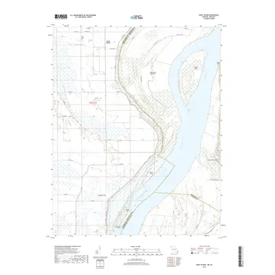
2017 Map of Wolf Island
USGS Topo · Published 2017About this map
The Mississippi River carves a complex path through the lowlands between Mississippi County, Missouri, and Hickman and Fulton Counties in Kentucky. This 2017 survey details the shifting alluvial landscape where state lines often follow the river's historic mid-channel rather than its current flow, leaving features like Wolf Island and Moore Island as prominent markers of the waterway's power. The Missouri side is notably dotted with family and community burial grounds, including Wolf Island Cem, Ivie Cem, Barnes Cem, and Lee Cem, which provide essential points of reference for genealogists tracking early families of this floodplain. Across the river in Kentucky, the terrain rises into steep elevations such as Chalk Bluff and Three Ponds Bluff. This map captures a modern view of a centuries-old transit corridor, where Obion Creek joins the river system near Beckwith Bend amidst a network of levee roads and drainage patterns.
Find a feature on this map
42 named features on this map. Tap any name to fly to it.
Don’t see what you’re looking for? This feature index may not catch every label — zoom into the map to look around manually.
Map Details
Editions of this 2017 Wolf Island Map
This is the sole edition of this map. No revisions or reprints were ever made.
Other maps of this area

1939 · Wickliffe
USGS Topo · 1:62,500

1939 · Charleston
USGS Topo · 1:62,500

1939 · Hickman
USGS Topo · 1:62,500

1939 · Bayouville
USGS Topo · 1:62,500

1951 · Cayce
USGS Topo · 1:24,000

1951 · Bondurant
USGS Topo · 1:24,000

1951 · Oakton
USGS Topo · 1:24,000

1951 · Hickman
USGS Topo · 1:24,000

1951 · Wolf Island
USGS Topo · 1:24,000

1951 · Wickliffe SW
USGS Topo · 1:24,000