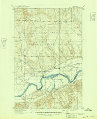
1916 Map of Wolf Point
USGS Topo · Published 1949About this map
The Missouri River winds through the heart of this landscape, serving as a boundary for both physical geography and early administrative lines. This 1916 era survey documents the Fort Peck Indian Reservation during a period of transition, showing the critical junction where the Great Northern railroad tracks parallel the river's northern bank. The settlement of Wolf Point stands as the primary hub, while the nearby sites of Oldtown and Macon indicate the shifting centers of local trade and transportation. Away from the river, the map reveals a scattered educational landscape with the Randolph School and Sand Creek School serving rural families. Tributaries like Wolf Creek and Fort Charles Creek carve paths through the terrain, illustrating the drainage patterns that defined early ranching and homesteading efforts in this part of northeastern Montana.
Find a feature on this map
15 named features on this map. Tap any name to fly to it.
Don’t see what you’re looking for? This feature index may not catch every label — zoom into the map to look around manually.
Map Details
Editions of this 1916 Wolf Point Map
2 editions found
Other maps of this area

1910 · Todd Lakes
USGS Topo · 1:62,500

1910 · Cuskers
USGS Topo · 1:62,500

1912 · Chelsea
USGS Topo · 1:62,500

1915 · Tule Valley
USGS Topo · 1:62,500

1915 · Oswego
USGS Topo · 1:62,500

1915 · Cuskers
USGS Topo · 1:62,500

1915 · Todd Lakes
USGS Topo · 1:62,500

1916 · Wolf Point
USGS Topo · 1:62,500

1954 · Glendive
USGS Topo · 1:250,000

1954 · Wolf Point
USGS Topo · 1:250,000
Featured Places
- Wolf Point District, MT
- Wolf Point, Wolf Point District
- Macon, Wolf Point District
- Roosevelt County, MT
- McCone County, MT