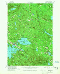
1958 Map of Wolfeboro
USGS Topo · Published 1965About this map
Lake Winnipesaukee and its winding shoreline define the southwestern portion of this Carroll County landscape, where the bustling hub of Wolfeboro sits as a gateway to the Lakes Region. This 1958 revision captures a classic New England lakefront economy, featuring Brewster Academy and the Huggins Hospital complex near the water's edge. The industrial and transit patterns of the mid-20th century are evident along the Boston and Maine Railroad, which links several specialized stations including Cotton Valley Station and Burleyville Station. Inland, the terrain rises sharply into the Ossipee Mts, dotted with isolated settlements like Water Village and Roland Park. The map also documents the transition from rail to highway culture, with the Governor Wentworth Highway skirting the eastern shores of Lake Wentworth and Wentworth State Park. Local life is further detailed through dozens of cemeteries and churches scattered from Tuftonboro to Sanbornville.
Find a feature on this map
161 named features on this map. Tap any name to fly to it.
Don’t see what you’re looking for? This feature index may not catch every label — zoom into the map to look around manually.
Map Details
Editions of this 1958 Wolfeboro Map
2 editions found

Other maps of this area

1891 · Berwick
USGS Topo · 1:62,500

1891 · Newfield
USGS Topo · 1:62,500

1893 · Berwick
USGS Topo · 1:62,500

1893 · Newfield
USGS Topo · 1:62,500

1909 · Winnepesaukee
USGS Topo · 1:62,500

1910 · Kezar Falls
USGS Topo · 1:48,000

1911 · Kezar Falls
USGS Topo · 1:62,500

1919 · Gilmanton
USGS Topo · 1:62,500

1919 · Alton
USGS Topo · 1:62,500

1927 · Gilmanton
USGS Topo · 1:62,500