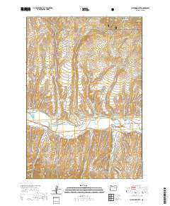
2020 Map of Wolfinger Butte
USGS Topo · Published 2020About this map
The John Day River carves a central path through this Grant County landscape, serving as the focal point for a complex network of agricultural irrigation. Vital water management is evidenced by the presence of the Eddington Ditch, Blue Mountain Ditch, and Lemons Ditch, which divert the river's flow to support the valley. In the western reaches, the Moon Creek Cem sits near the mouth of Waterspout Gulch, offering a specific point of interest for genealogists tracing local families.
Find a feature on this map
45 named features on this map. Tap any name to fly to it.
Don’t see what you’re looking for? This feature index may not catch every label — zoom into the map to look around manually.
Map Details
Editions of this 2020 Wolfinger Butte Map
This is the sole edition of this map. No revisions or reprints were ever made.
Other maps of this area

1940 · Mount Vernon
USGS Topo · 1:62,500

1940 · Aldrich Mtn.
USGS Topo · 1:62,500

1943 · Aldrich Mtn.
USGS Topo · 1:62,500

1943 · Mount Vernon
USGS Topo · 1:62,500

1949 · Long Creek
USGS Topo · 1:62,500

1951 · Long Creek
USGS Topo · 1:62,500

1951 · Courtrock
USGS Topo · 1:62,500

1955 · Canyon City
USGS Topo · 1:250,000

1959 · Canyon City
USGS Topo · 1:250,000

1972 · Big Weasel Sprs
USGS Topo · 1:24,000