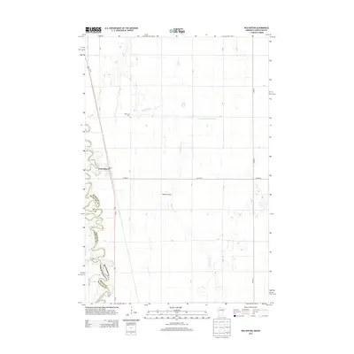
2013 Map of Wolverton
USGS Topo · Published 2013About this map
The Wolverton townsite sits prominently on the eastern bank of the Red River, which defines the border between Minnesota and North Dakota. This agricultural landscape is characterized by a precise grid of rural roads and drainage infrastructure essential to the Red River Valley, including the long stretch of County Ditch Number Five A and the winding course of Wolverton Cr. Genealogists will find the Wolverton Cem situated north of the main settlement along a section line road. The town itself is centered around the Po, serving as a local hub for the surrounding Wilkin County farmland. Distinctive natural drainages like Nyquist Coulee cut through the otherwise flat terrain, illustrating the hydrologic patterns of this border region in the early 21st century.
Find a feature on this map
27 named features on this map. Tap any name to fly to it.
Don’t see what you’re looking for? This feature index may not catch every label — zoom into the map to look around manually.
Map Details
Editions of this 2013 Wolverton Map
This is the sole edition of this map. No revisions or reprints were ever made.
Other maps of this area

1895 · Fargo
USGS Topo · 1:125,000

1897 · Fargo
USGS Topo · 1:125,000

1904 · Wahpeton
USGS Topo · 1:125,000

1953 · Fargo
USGS Topo · 1:250,000

1956 · Fargo
USGS Topo · 1:250,000

1959 · Hickson
USGS Topo · 1:24,000

1959 · Christine
USGS Topo · 1:24,000

1960 · Galchutt
USGS Topo · 1:24,000

1964 · Baker
USGS Topo · 1:24,000
1964 · Comstock
USGS Topo · 1:24,000