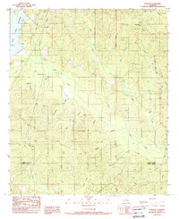
1989 Map of Womack
USGS Topo · Published 1989About this map
The community of Womack lies in the northern reaches of this Jackson Parish landscape, a region defined by its complex network of small waterways and timberlands in the late 1980s. The terrain is marked by numerous family-named branches and creeks, such as Cane Mill Branch and Honeycutt Branch, which feed into the larger Reservoir and Caney Creek. To the east, Hoods Mill and a prominent Lookout Tower suggest the area's historical ties to the lumber industry and forest management. Small settlements like Gulf Crossing, Batiste, and Lyons are scattered throughout, connected by a network of roads that includes an Old RR Grade, indicating the path of former logging or industrial rail lines that once served the rural parishes of Jackson and Winn.
Find a feature on this map
32 named features on this map. Tap any name to fly to it.
Don’t see what you’re looking for? This feature index may not catch every label — zoom into the map to look around manually.
Map Details
Editions of this 1989 Womack Map
This is the sole edition of this map. No revisions or reprints were ever made.
Other maps of this area

1949 · Jonesboro
USGS Topo · 1:62,500

1950 · Jonesboro
USGS Topo · 1:62,500

1953 · Chatham
USGS Topo · 1:62,500

1953 · Hodge
USGS Topo · 1:62,500

1954 · Sikes
USGS Topo · 1:62,500

1955 · Shreveport
USGS Topo · 1:250,000

1956 · Shreveport
USGS Topo · 1:250,000

1982 · Chatham
USGS Topo · 1:24,000

1982 · Chatham SE
USGS Topo · 1:24,000

1984 · Shreveport
USGS Topo · 1:250,000