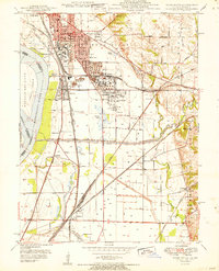
1951 Map of Wood River
USGS Topo · Published 1951About this map
Industrial infrastructure and river management dominate this 1951 study of the Mississippi River floodplain in Madison County. Extensive Oil Refinery complexes and an Oil Reservoir at Wood River and Roxana signal the region's mid-century economic engine, supported by a dense rail network including the Terminal RR and the Wabash RR. The landscape reveals a complex relationship with water, where the Mississippi River meets the Cahokia Diversion Channel and the Old Channel Wood River.
Find a feature on this map
63 named features on this map. Tap any name to fly to it.
Don’t see what you’re looking for? This feature index may not catch every label — zoom into the map to look around manually.
Map Details
Editions of this 1951 Wood River Map
This is the sole edition of this map. No revisions or reprints were ever made.
Other maps of this area

1888 · St. Louis
USGS Topo · 1:62,500

1907 · Belleville
USGS Topo · 1:62,500

1927 · Alton
USGS Topo · 1:62,500

1927 · Edwardsville
USGS Topo · 1:62,500

1932 · Edwardsville
USGS Topo · 1:62,500

1933 · Granite City
USGS Topo · 1:24,000

1934 · Alton
USGS Topo · 1:62,500

1935 · Granite City
USGS Topo · 1:24,000

1935 · Monks Mound
USGS Topo · 1:24,000

1935 · Columbia Bottom
USGS Topo · 1:24,000