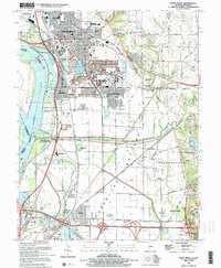
1994 Map of Wood River
USGS Topo · Published 1995About this map
Industrial and educational landscapes define this corner of Madison County in the 1990s, where the infrastructure of Wood River and Roxana meets the floodplain of the American Bottoms. A massive Oil Refinery and the sprawling campus of Southern Illinois University (Edwardsville) anchor the regional economy, while the Mississippi River remains the dominant geographic force. The map documents the intricate water management of the lowlands, including the Cahokia Diversion Channel and the Chain of Rocks Canal. For local historians, the sheet preserves the locations of smaller communities like Poag, Mitchell, and Wanda, alongside older burial grounds such as Springley Cem and Pioneer Cem. The landscape is further fragmented by rail lines like the Illinois Terminal RR and the Conrail network, illustrating the area's role as a major transportation corridor near the Missouri border.
Find a feature on this map
64 named features on this map. Tap any name to fly to it.
Don’t see what you’re looking for? This feature index may not catch every label — zoom into the map to look around manually.
Map Details
Editions of this 1994 Wood River Map
2 editions found
Other maps of this area

1888 · St. Louis
USGS Topo · 1:62,500

1907 · Belleville
USGS Topo · 1:62,500

1927 · Alton
USGS Topo · 1:62,500

1927 · Edwardsville
USGS Topo · 1:62,500

1932 · Edwardsville
USGS Topo · 1:62,500

1933 · Granite City
USGS Topo · 1:24,000

1934 · Alton
USGS Topo · 1:62,500

1935 · Granite City
USGS Topo · 1:24,000

1935 · Monks Mound
USGS Topo · 1:24,000

1935 · Columbia Bottom
USGS Topo · 1:24,000