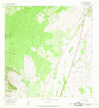
1967 Map of Wood Valley
USGS Topo · Published 1968About this map
The Kapapala Ranch and the organized plots of the Wood Valley Homesteads anchor this 1967 survey of the Kau District's volcanic slopes. The landscape is defined by the stark contrast between the dense Kau Forest Reserve to the west and the expansive lava fields of Hawaii Volcanoes National Park to the east. Notable geological features like the Great Crack and the Keamoku Lava Flow of 1823 reveal the area's active volcanic history, while cultural markers such as Kapapala Cave (Petroglyphs) and the Cem near Wood Valley Camp speak to long-standing human presence.
Find a feature on this map
46 named features on this map. Tap any name to fly to it.
Don’t see what you’re looking for? This feature index may not catch every label — zoom into the map to look around manually.
Map Details
Editions of this 1967 Wood Valley Map
2 editions found
Other maps of this area

1921 · Kilauea
USGS Topo · 1:62,500

1923 · Pahala
USGS Topo · 1:62,500

1924 · Kilauea
USGS Topo · 1:62,500

1924 · Honuapo
USGS Topo · 1:62,500

1928 · Mauna Loa
USGS Topo · 1:62,500

1954 · Hawaii South
USGS Topo · 1:250,000

1959 · Hawaii South
USGS Topo · 1:250,000

1961 · Hawaii South
USGS Topo · 1:250,000

1962 · Hawaii South
USGS Topo · 1:250,000
1963 · Kau Desert
USGS Topo · 1:24,000