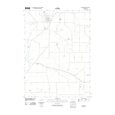
2010 Map of Woodbine
USGS Topo · Published 2010About this map
The town of Woodbine serves as the primary hub of this Harrison County landscape, situated along the banks of the Boyer River. The settlement pattern follows the drainage of various waterways, including Picayune Creek, Sixmile Creek, and Richardson Creek, which carve through the Iowa terrain. A high density of rural burial grounds is a defining characteristic of this sheet, offering a significant resource for genealogical research. These include the Woodbine Cemetery near the town center and more remote locations like Mefferd Cemetery, Cowan-Pardee Cemetery, Ellison Cemetery, and McGovern Cemetery. Smaller community clusters and place names such as Jeddo City, Whitesboro, and Ojedo provide insight into the historical distribution of residents outside the main municipality. Local infrastructure is represented by the Woodbine Post Office and the Woodbine Municipal Airport, while a network of rural routes like Quincy Trl and Rockville Ave connect the outlying farmsteads.
Find a feature on this map
58 named features on this map. Tap any name to fly to it.
Don’t see what you’re looking for? This feature index may not catch every label — zoom into the map to look around manually.
Map Details
Editions of this 2010 Woodbine Map
This is the sole edition of this map. No revisions or reprints were ever made.
Other maps of this area

1954 · Omaha
USGS Topo · 1:250,000

1957 · Omaha
USGS Topo · 1:250,000

1958 · Omaha
USGS Topo · 1:250,000

1970 · Logan
USGS Topo · 1:24,000
1970 · Beebeetown
USGS Topo · 1:24,000

1971 · Moorhead SE
USGS Topo · 1:24,000

1971 · Dunlap SW
USGS Topo · 1:24,000

1971 · Dunlap
USGS Topo · 1:24,000
1978 · Hard Scratch
USGS Topo · 1:24,000

1978 · Persia
USGS Topo · 1:24,000