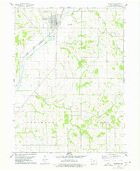
1978 Map of Woodbine
USGS Topo · Published 1978About this map
The Boyer River valley serves as a primary corridor for transportation and settlement in this late-1970s landscape. The town of Woodbine stands as the central hub, situated at the junction of the Chicago and North Western and Illinois Central Gulf railroads, illustrating the area's continued reliance on rail infrastructure for agricultural commerce. Beyond the town grid, the landscape is defined by the winding paths of Picayune Creek, Sixmile Creek, and Richardson Creek, which carve through the loess hills of Harrison County.
Find a feature on this map
21 named features on this map. Tap any name to fly to it.
Don’t see what you’re looking for? This feature index may not catch every label — zoom into the map to look around manually.
Map Details
Editions of this 1978 Woodbine Map
This is the sole edition of this map. No revisions or reprints were ever made.
Other maps of this area

1954 · Omaha
USGS Topo · 1:250,000

1957 · Omaha
USGS Topo · 1:250,000

1958 · Omaha
USGS Topo · 1:250,000

1970 · Logan
USGS Topo · 1:24,000
1970 · Beebeetown
USGS Topo · 1:24,000

1971 · Moorhead SE
USGS Topo · 1:24,000

1971 · Dunlap SW
USGS Topo · 1:24,000

1971 · Dunlap
USGS Topo · 1:24,000
1978 · Hard Scratch
USGS Topo · 1:24,000

1978 · Persia
USGS Topo · 1:24,000