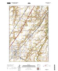
2020 Map of Woodburn
USGS Topo · Published 2020About this map
French Prairie and Elliott Prairie define the agricultural character of this Marion County landscape, where the meandering Pudding River forms a natural eastern boundary. The central hub of Woodburn shows a dense grid of residential development, supported by its proximity to the regional transport artery of Interstate 5 and the historical crossroads of the northern Willamette Valley. Smaller settlements like Donald, Hubbard, and Aurora are connected by a network of rural routes such as Boones Ferry Rd NE and Butteville Rd NE.
Find a feature on this map
158 named features on this map. Tap any name to fly to it.
Don’t see what you’re looking for? This feature index may not catch every label — zoom into the map to look around manually.
Map Details
Editions of this 2020 Woodburn Map
This is the sole edition of this map. No revisions or reprints were ever made.
Other maps of this area

1914 · Oregon City
USGS Topo · 1:62,500

1916 · Tualatin
USGS Topo · 1:62,500

1923 · Mount Angel
USGS Topo · 1:62,500

1939 · Molalla
USGS Topo · 1:62,500

1939 · Oregon City
USGS Topo · 1:62,500

1939 · Tualatin
USGS Topo · 1:62,500

1940 · Tualatin
USGS Topo · 1:62,500

1940 · Molalla
USGS Topo · 1:62,500

1940 · Mount Angel
USGS Topo · 1:62,500

1941 · Oregon City
USGS Topo · 1:62,500