
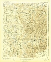
1908 Map of Woodbury
USGS Topo · Published 1908About this map
Woodbury serves as the focal point of this 1906 survey, situated at the confluence of the East Fork Stone River and its numerous tributaries. The landscape is defined by the sharp transition from the fertile valleys of the Stone River basin to the higher elevation of the Plateau of the Barrens in the southeast. This era's rural infrastructure is extensively documented, showing a network of toll roads such as the Murfreesboro Turnpike and essential community hubs like Hoovers Mill and McPeaks Mill.
Find a feature on this map
97 named features on this map. Tap any name to fly to it.
Don’t see what you’re looking for? This feature index may not catch every label — zoom into the map to look around manually.
Map Details
Editions of this 1908 Woodbury Map
2 editions found
Other maps of this area

1893 · Mc Minnville
USGS Topo · 1:125,000

1895 · Mc Minnville
USGS Topo · 1:125,000

1913 · Hollow Springs
USGS Topo · 1:62,500

1916 · Murfreesboro
USGS Topo · 1:62,500

1928 · Gordonsville
USGS Topo · 1:62,500

1936 · Webbs Jungle
USGS Topo · 1:24,000

1936 · Beech Grove
USGS Topo · 1:24,000

1936 · Petty Gap
USGS Topo · 1:24,000

1942 · Statesville
USGS Topo · 1:100,000

1942 · Lebanon
USGS Topo · 1:100,000