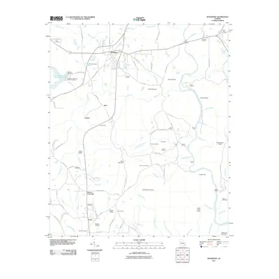
2011 Map of Woodbury
USGS Topo · Published 2011About this map
Woodbury serves as the primary hub in this Georgia landscape, situated where local routes converge north of the Flint River. The terrain is defined by a series of distinct ridges and hollows, including Dixon Mountain and the prominent Huckleberry Pinnacle. This 2011 survey documents a rural environment deeply connected to its past through numerous family and community landmarks. Researchers can trace the legacy of early industry at Sees Old Mill and identify the distribution of long-standing rural settlements such as Johnson Crossroads, Persico, and Loftin. The map's detailed recording of the Flint River corridor reveals geographical features like Dripping Rocks and the Iron Bridge crossing, alongside numerous small family burial grounds including the Gilbert Cemetery and Bowman Cemetery. The western portion is marked by water management features such as the Cane Creek Structure Number Two Lake, illustrating the more recent hydrological changes to the local drainage basins.
Find a feature on this map
102 named features on this map. Tap any name to fly to it.
Don’t see what you’re looking for? This feature index may not catch every label — zoom into the map to look around manually.
Map Details
Editions of this 2011 Woodbury Map
This is the sole edition of this map. No revisions or reprints were ever made.
Other maps of this area

1907 · Talbotton
USGS Topo · 1:125,000

1934 · Warm Springs
USGS Topo · 1:62,500

1935 · Thomaston
USGS Topo · 1:48,000

1936 · Warm Springs
USGS Topo · 1:62,500

1939 · Thomaston
USGS Topo · 1:62,500

1953 · Atlanta
USGS Topo · 1:250,000

1955 · Phenix City
USGS Topo · 1:250,000

1957 · Phenix City
USGS Topo · 1:250,000

1957 · Atlanta
USGS Topo · 1:250,000

1958 · Phenix City
USGS Topo · 1:250,000