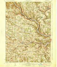
1926 Map of Woodhull
USGS Topo · Published 1926About this map
The Canisteo River valley serves as the primary corridor for commerce and transport across this portion of Steuben County, defined by the winding route of the Erie RR. This 1920s landscape reveals an incredibly dense network of rural education, with dozens of family-named and neighborhood institutions such as Eight Square School, Roosa School, and Gothic School serving the upland dairy and farming communities. The terrain is deeply dissected by tributaries like Tuscarora Creek and Goodhue Creek, which carve through the high plateaus between the larger settlements of Woodhull and Cameron. This period represents the peak of rural infrastructure before the consolidation of local school districts, capturing specific hamlets like Cameron Mills and Hedgesville at a time when small-scale agriculture and local rail stations were the foundations of the regional economy.
Find a feature on this map
102 named features on this map. Tap any name to fly to it.
Don’t see what you’re looking for? This feature index may not catch every label — zoom into the map to look around manually.
Map Details
Editions of this 1926 Woodhull Map
4 editions found

Other maps of this area

1899 · Gaines
USGS Topo · 1:62,500

1900 · Gaines
USGS Topo · 1:62,500

1900 · Tioga
USGS Topo · 1:62,500

1900 · Elkland
USGS Topo · 1:62,500

1902 · Tioga
USGS Topo · 1:62,500

1903 · Hammondsport
USGS Topo · 1:62,500

1910 · Bath
USGS Topo · 1:62,500

1914 · Corning
USGS Topo · 1:62,500

1915 · Hornell
USGS Topo · 1:62,500

1918 · Hornell
USGS Topo · 1:62,500