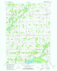
1981 Map of Woodland
USGS Topo · Published 1981About this map
Woodland sits as the primary settlement in this corner of Barry County, anchored by a grid of rural roads and small water bodies that define the local landscape. The Thornapple River and its various tributaries, including the Little Thornapple River and Butler Creek, create a complex drainage network across the townships of Carlton, Woodland, Hastings, and Castleton. This 1981 survey illustrates a well-established agricultural and rural residential pattern, with dispersed landmarks like the Grange Hall and Wood Grove Ch serving the outlying community.
Find a feature on this map
37 named features on this map. Tap any name to fly to it.
Don’t see what you’re looking for? This feature index may not catch every label — zoom into the map to look around manually.
Map Details
Editions of this 1981 Woodland Map
This is the sole edition of this map. No revisions or reprints were ever made.
Other maps of this area

1916 · Ionia
USGS Topo · 1:62,500

1918 · Ionia
USGS Topo · 1:62,500

1918 · Lowell
USGS Topo · 1:62,500

1943 · Ionia
USGS Topo · 1:62,500

1943 · Lowell
USGS Topo · 1:62,500

1950 · Nashville
USGS Topo · 1:62,500

1951 · Nashville
USGS Topo · 1:62,500

1951 · Hastings
USGS Topo · 1:62,500

1958 · Grand Rapids
USGS Topo · 1:250,000

1961 · Grand Rapids
USGS Topo · 1:250,000
Featured Places
- Woodland, Woodland Township
- Woodland Township, MI
- Carlton Township, MI
- Castleton Township, MI
- Hastings Township, MI