1971 Map of Woodland
USGS Topo · Published 1973About this map
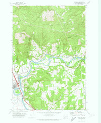
The Lewis River serves as the primary corridor of this 1971 landscape, forming the boundary between Cowlitz and Clark counties. The town of Woodland is positioned at the river’s bend, characterized by the distinct crescent of Horseshoe Lake and the nearby Wallace Slough. Settlement patterns extend eastward along the river valley and into the hills, where small communities like Finn Hall, Hayes, and Highland are established. Rural life is further evidenced by several family-named landmarks and historical burial grounds, including the Abel Cem and Highland Cem.
Find a feature on this map
42 named features on this map. Tap any name to fly to it.
Don’t see what you’re looking for? This feature index may not catch every label — zoom into the map to look around manually.
Map Details
Editions of this 1971 Woodland Map
This is the sole edition of this map. No revisions or reprints were ever made.
Other maps of this area

1921 · Kalama
USGS Topo · 1:62,500

1922 · St. Helens
USGS Topo · 1:62,500

1940 · La Center
USGS Topo · 1:62,500

1941 · St Helens
USGS Topo · 1:62,500

1943 · Pigeon Springs
USGS Topo · 1:62,500

1943 · St Helens
USGS Topo · 1:62,500

1948 · Vancouver
USGS Topo · 1:250,000

1950 · Vancouver
USGS Topo · 1:250,000

1950 · Vancouver
USGS Topo · 1:250,000

1953 · Hoquiam
USGS Topo · 1:250,000