1994 Map of Woodland Park
USGS Topo · Published 1998About this map
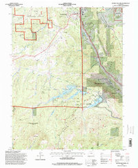
Woodland Park serves as the primary hub in this high-altitude landscape where the Rampart Range meets the northern slopes of Pikes Peak. The map highlights a sophisticated water management system integrated into the Pike National Forest, featuring the North Catamount Reservoir, South Catamount Reservoir, and Crystal Creek Reservoir. These bodies of water are interconnected by infrastructure like the Homestake Delivery Aqueduct, illustrating the complex engineering required to support mountain communities and downstream needs.
Find a feature on this map
44 named features on this map. Tap any name to fly to it.
Don’t see what you’re looking for? This feature index may not catch every label — zoom into the map to look around manually.
Map Details
Editions of this 1994 Woodland Park Map
This is the sole edition of this map. No revisions or reprints were ever made.
Other maps of this area

1893 · Platte Canyon
USGS Topo · 1:125,000

1893 · Colorado Springs
USGS Topo · 1:125,000

1894 · Pikes Peak
USGS Topo · 1:125,000

1894 · Castle Rock
USGS Topo · 1:125,000

1901 · Pikes Peak
USGS Topo · 1:125,000

1901 · Pikes Peak
USGS Topo · 1:62,500

1909 · Colorado Springs
USGS Topo · 1:125,000

1913 · Castle Rock
USGS Topo · 1:125,000

1942 · Colorado Springs
USGS Topo · 1:125,000
1948 · Manitou Springs
USGS Topo · 1:24,000