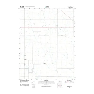
2009 Map of Woodlawn
USGS Topo · Published 2009About this map
Capioma and Woodlawn anchor this agricultural landscape in Nemaha County, where the township grid meets a network of vital waterways. The terrain is defined by the drainage of the Delaware River and the meandering paths of Grasshopper Creek, Muddy Creek, and Plum Creek. This 2009 survey highlights the intersection of rural life and natural hydrology, showing the placement of the Woodlawn Cemetery along Woodlawn Rd and the small junctions of Fidelity and Fourmile Corners. The road system, including Wetmore Sabetha Rd and Acorn Rd, reveals how the settlement pattern was dictated by both the square-mile sections and the intervening creek valleys like those of Cedar Creek and Craig Creek.
Find a feature on this map
18 named features on this map. Tap any name to fly to it.
Don’t see what you’re looking for? This feature index may not catch every label — zoom into the map to look around manually.
Map Details
Editions of this 2009 Woodlawn Map
This is the sole edition of this map. No revisions or reprints were ever made.
Other maps of this area

1888 · Hiawatha
USGS Topo · 1:125,000

1894 · Hiawatha
USGS Topo · 1:125,000

1950 · Kansas City
USGS Topo · 1:250,000

1954 · Kansas City
USGS Topo · 1:250,000

1956 · Kansas City
USGS Topo · 1:250,000
1959 · Morrill
USGS Topo · 1:24,000

1960 · Kansas City
USGS Topo · 1:250,000
1960 · Bern
USGS Topo · 1:24,000
1960 · Sabetha
USGS Topo · 1:24,000

1960 · Fairview
USGS Topo · 1:24,000