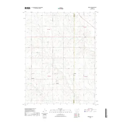
2018 Map of Woodlawn
USGS Topo · Published 2018About this map
Woodlawn and Capioma anchor this rural landscape along the boundary of Nemaha and Brown counties, where a network of section roads like 124th Rd and 200th St divide the rolling agricultural terrain. The area is defined by its small, scattered settlements and the headwaters of the Delaware River, which wind through the eastern reaches of the quadrangle alongside smaller drainage systems like Craig Cr and Muddy Cr. This 21st-century perspective shows a landscape deeply rooted in its local history, evidenced by the preservation of sacred sites such as Woodlawn Cem and Caploma Cem. The tiny hamlet of Fidelity sits near the county line, while Saint Augustine's Cem serves as a landmark for the community nearby. These features reveal a region that has maintained its pastoral character even as modern infrastructure like 36 and 75 pass through its northern and eastern corridors.
Find a feature on this map
41 named features on this map. Tap any name to fly to it.
Don’t see what you’re looking for? This feature index may not catch every label — zoom into the map to look around manually.
Map Details
Editions of this 2018 Woodlawn Map
This is the sole edition of this map. No revisions or reprints were ever made.
Other maps of this area

1888 · Hiawatha
USGS Topo · 1:125,000

1894 · Hiawatha
USGS Topo · 1:125,000

1950 · Kansas City
USGS Topo · 1:250,000

1954 · Kansas City
USGS Topo · 1:250,000

1956 · Kansas City
USGS Topo · 1:250,000
1959 · Morrill
USGS Topo · 1:24,000

1960 · Kansas City
USGS Topo · 1:250,000
1960 · Bern
USGS Topo · 1:24,000
1960 · Sabetha
USGS Topo · 1:24,000

1960 · Fairview
USGS Topo · 1:24,000