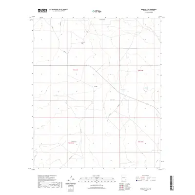
2020 Map of Woodley Flat
USGS Topo · Published 2020About this map
Ochoa and the surrounding expanse of Lea County represent a landscape defined by the logistics of the high desert and the ranching economy. This map illustrates the vital importance of water management in the region, centered on the Antelope Draw and a network of named livestock watering points such as Allison Tank, Vivian Tank, and Johnson Grass Tank. The terrain is marked by the prominent Antelope Ridge, which provides a geographic anchor for the rural road network, including Antelope Rd and Battle Axe Rd. While Woodley Flat sits in the southern portion of the sheet, the overall pattern of the land is one of large-scale ranching and mineral exploration infrastructure. The presence of these named tanks and rugged tracks offers a clear record of how this part of southeastern New Mexico was navigated and utilized in the early twenty-first century.
Find a feature on this map
18 named features on this map. Tap any name to fly to it.
Don’t see what you’re looking for? This feature index may not catch every label — zoom into the map to look around manually.
Map Details
Editions of this 2020 Woodley Flat Map
This is the sole edition of this map. No revisions or reprints were ever made.
Other maps of this area

1954 · Hobbs
USGS Topo · 1:250,000

1958 · Hobbs
USGS Topo · 1:250,000

1963 · Oil Center
USGS Topo · 1:62,500

1963 · Hat Mesa
USGS Topo · 1:62,500

1973 · Javelina Basin
USGS Topo · 1:24,000

1973 · Bell Lake
USGS Topo · 1:24,000

1973 · Paduca Breaks East
USGS Topo · 1:24,000

1973 · Custer Mountain
USGS Topo · 1:24,000
1973 · Andrews Place
USGS Topo · 1:24,000
1973 · Woodley Flat
USGS Topo · 1:24,000