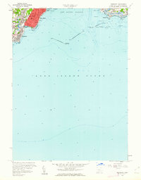
1960 Map of Woodmont
USGS Topo · Published 1962About this map
New Haven Lighthouse and the Southwest Ledge Lighthouse guard the entrance to New Haven Harbor in this 1960 coastal study. The map shows the suburban development of West Haven and East Haven following the introduction of the Connecticut Turnpike, which slices through the landscape to the north. While the inland areas show dense residential grids around Haley Sch and Linwood Sch, the shoreline remains defined by its recreational and maritime character.
Find a feature on this map
44 named features on this map. Tap any name to fly to it.
Don’t see what you’re looking for? This feature index may not catch every label — zoom into the map to look around manually.
Map Details
Editions of this 1960 Woodmont Map
3 editions found
Other maps of this area

1889 · Derby
USGS Topo · 1:62,500

1891 · Bridgeport
USGS Topo · 1:62,500

1891 · Derby
USGS Topo · 1:62,500

1892 · New Haven
USGS Topo · 1:62,500

1893 · Bridgeport
USGS Topo · 1:62,500

1893 · Derby
USGS Topo · 1:62,500

1920 · Bridgeport
USGS Topo · 1:62,500

1921 · New Haven
USGS Topo · 1:62,500

1943 · New Haven
USGS Topo · 1:31,680

1947 · Hartford
USGS Topo · 1:250,000