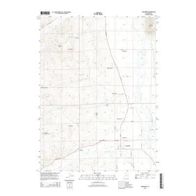
2014 Map of Woodruff
USGS Topo · Published 2014About this map
The high mountain valley of the Bear River anchors this 2014 topographic study of Rich County, Utah. The settlement of Woodruff serves as the focal point, situated at the intersection of W Center St and S Highway 16. The surrounding landscape is defined by a sophisticated system of irrigation and water management, including the Sidehill Ditch and Pump Ditch, which support the agricultural life of Woodruff Pastures. For genealogists, the map preserves the location of the Woodruff Cem and the Eastman Family Cem, the latter situated near the winding path of Woodruff Cr. The terrain rises sharply to the east into the Crawford Mountains and to the west toward landmarks like Limestone Peak and Sugarloaf. A network of localized water storage, such as Limestone Reservoir and Higgins Hollow Reservoir, illustrates the reliance on seasonal runoff from the higher elevations of Thousand Dollar Rdg.
Find a feature on this map
53 named features on this map. Tap any name to fly to it.
Don’t see what you’re looking for? This feature index may not catch every label — zoom into the map to look around manually.
Map Details
Editions of this 2014 Woodruff Map
This is the sole edition of this map. No revisions or reprints were ever made.
Other maps of this area

1912 · Randolph
USGS Topo · 1:125,000

1954 · Ogden
USGS Topo · 1:250,000

1958 · Ogden
USGS Topo · 1:250,000

1960 · Ogden
USGS Topo · 1:250,000

1968 · Rex Peak
USGS Topo · 1:24,000

1968 · Randolph
USGS Topo · 1:24,000

1968 · Woodruff
USGS Topo · 1:24,000

1968 · Neponset Reservoir NE
USGS Topo · 1:24,000

1968 · Meachum Ridge
USGS Topo · 1:24,000
1968 · Woodruff Narrows
USGS Topo · 1:24,000