
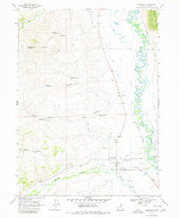
1968 Map of Woodruff
USGS Topo · Published 1970About this map
The settlement of Woodruff sits at the heart of this high-desert landscape, where the waters of Woodruff Creek and Genes Creek converge before meeting the Bear River. The map reveals a complex system of water management essential for survival in this arid terrain, featuring numerous irrigation works like the Sage Creek Canal, Crawford Canal, and Thompson Canal. These man-made waterways parallel the winding river, supporting the homesteads and agriculture of Rich County.
Find a feature on this map
33 named features on this map. Tap any name to fly to it.
Don’t see what you’re looking for? This feature index may not catch every label — zoom into the map to look around manually.
Map Details
Editions of this 1968 Woodruff Map
2 editions found
Other maps of this area

1912 · Randolph
USGS Topo · 1:125,000

1954 · Ogden
USGS Topo · 1:250,000

1958 · Ogden
USGS Topo · 1:250,000

1960 · Ogden
USGS Topo · 1:250,000

1968 · Rex Peak
USGS Topo · 1:24,000

1968 · Randolph
USGS Topo · 1:24,000

1968 · Neponset Reservoir NE
USGS Topo · 1:24,000

1968 · Meachum Ridge
USGS Topo · 1:24,000
1968 · Woodruff Narrows
USGS Topo · 1:24,000
1968 · Neponset Reservoir NW
USGS Topo · 1:24,000