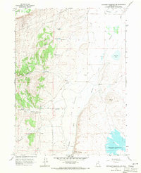
1968 Map of Neponset Reservoir NW
USGS Topo · Published 1971About this map
Neponset Reservoir anchors this high-elevation landscape in Rich County, showing a sparse, ranching-oriented environment at the end of the 1960s. The terrain is defined by a series of prominent drainage systems including Saleratus Creek and Woodruff Creek, which feed into the reservoir from the surrounding uplands. A human presence is marked by isolated features such as the Home Ranch and an adjacent Landing Strip, signifying the logistical needs of remote agricultural operations in this part of northern Utah.
Find a feature on this map
34 named features on this map. Tap any name to fly to it.
Don’t see what you’re looking for? This feature index may not catch every label — zoom into the map to look around manually.
Map Details
Editions of this 1968 Neponset Reservoir NW Map
3 editions found
Other maps of this area

1912 · Randolph
USGS Topo · 1:125,000

1954 · Ogden
USGS Topo · 1:250,000

1958 · Ogden
USGS Topo · 1:250,000

1960 · Ogden
USGS Topo · 1:250,000

1968 · Woodruff
USGS Topo · 1:24,000

1968 · Mc Kay Hollow
USGS Topo · 1:24,000

1968 · Neponset Reservoir NE
USGS Topo · 1:24,000

1968 · Meachum Ridge
USGS Topo · 1:24,000

1968 · Peck Canyon
USGS Topo · 1:24,000
1968 · Woodruff Narrows
USGS Topo · 1:24,000