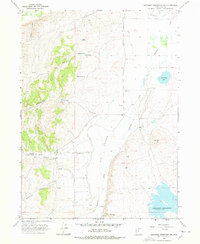
1968 Map of Neponset Reservoir NW
USGS Topo · Published 1978About this map
Big Meadow and the valley of Saleratus Creek anchor this high-altitude landscape in Rich County, where water sources dictate the placement of ranching infrastructure. The map reveals a reliance on isolated water points like Cabin Hollow Springs, Harris Hollow Spring, and Halfway Spring to support livestock in the drainages east of the highlands. Significant landmarks include the Home Ranch and a remote Landing Strip, suggesting the logistics of remote mountain living during the late 1960s. To the southeast, the Neponset Reservoir provides a critical irrigation source for the region. The terrain is defined by deep cuts such as Wheatgrass Hollow and Meachum Canyon, leading down toward the flats where the Blue Grass Pond sits near the base of Red Hill.
Find a feature on this map
36 named features on this map. Tap any name to fly to it.
Don’t see what you’re looking for? This feature index may not catch every label — zoom into the map to look around manually.
Map Details
Editions of this 1968 Neponset Reservoir NW Map
3 editions found
Other maps of this area

1912 · Randolph
USGS Topo · 1:125,000

1954 · Ogden
USGS Topo · 1:250,000

1958 · Ogden
USGS Topo · 1:250,000

1960 · Ogden
USGS Topo · 1:250,000

1968 · Woodruff
USGS Topo · 1:24,000

1968 · Mc Kay Hollow
USGS Topo · 1:24,000

1968 · Neponset Reservoir NE
USGS Topo · 1:24,000

1968 · Meachum Ridge
USGS Topo · 1:24,000

1968 · Peck Canyon
USGS Topo · 1:24,000
1968 · Woodruff Narrows
USGS Topo · 1:24,000