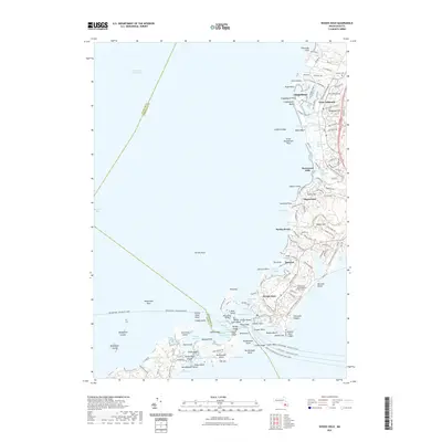
2021 Map of Woods Hole
USGS Topo · Published 2021About this map
Woods Hole and the surrounding southwestern coastline of Cape Cod are shown here, defined by a complex network of harbors, ponds, and residential enclaves along Buzzards Bay. The map documents the established maritime and scientific character of the region, anchored by the Woods Hole Oceanographic Institution and the busy ferry routes of the Martha's Vineyard and Woods Hole Ferry. To the north, the coastline transitions into the protected wetlands of Great Sippewisset Marsh and Little Sippewisset Marsh, separating the residential neighborhoods of West Falmouth and Saconesset Hills. The intricate topography includes many family-named landmarks like Crowell Cem and Telegraph Hill, alongside prominent coastal features such as The Knob and the narrow spit of Penzance.
Find a feature on this map
149 named features on this map. Tap any name to fly to it.
Don’t see what you’re looking for? This feature index may not catch every label — zoom into the map to look around manually.
Map Details
Editions of this 2021 Woods Hole Map
This is the sole edition of this map. No revisions or reprints were ever made.
Other maps of this area

1885 · New Bedford
USGS Topo · 1:62,500

1886 · Falmouth
USGS Topo · 1:62,500

1887 · Gay Head
USGS Topo · 1:62,500

1887 · Marthas Vineyard
USGS Topo · 1:62,500

1888 · New Bedford
USGS Topo · 1:62,500

1888 · Falmouth
USGS Topo · 1:62,500

1889 · Gay Head
USGS Topo · 1:62,500

1889 · Marthas Vineyard
USGS Topo · 1:62,500

1893 · Gay Head
USGS Topo · 1:62,500

1893 · Falmouth
USGS Topo · 1:62,500