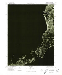
1977 Map of Woods Hole
USGS Topo · Published 1981About this map
Woods Hole and the surrounding coastline of Upper Cape Cod appear in high-contrast detail on this 1977 orthophotoquad. The imagery reveals the dense settlement patterns of Falmouth and the smaller harbors of West Falmouth and Quissett along the eastern shore of Buzzards Bay. The complex interface of land and sea is evident in the jagged peninsulas and sheltered inlets that define the villages of Sippewissett and the famous scientific hub at the Cape's southwestern tip. Across the waters of Vineyard Sound, the northern reaches of Naushon Island are visible, showing the relatively undeveloped character of the Elizabeth Islands compared to the mainland. This aerial-based perspective provides local historians a clear view of road networks and coastal development just before the significant growth of the late twentieth century.
Find a feature on this map
8 named features on this map. Tap any name to fly to it.
Don’t see what you’re looking for? This feature index may not catch every label — zoom into the map to look around manually.
Map Details
Editions of this 1977 Woods Hole Map
This is the sole edition of this map. No revisions or reprints were ever made.
Other maps of this area

1885 · New Bedford
USGS Topo · 1:62,500

1886 · Falmouth
USGS Topo · 1:62,500

1887 · Gay Head
USGS Topo · 1:62,500

1887 · Marthas Vineyard
USGS Topo · 1:62,500

1888 · New Bedford
USGS Topo · 1:62,500

1888 · Falmouth
USGS Topo · 1:62,500

1889 · Gay Head
USGS Topo · 1:62,500

1889 · Marthas Vineyard
USGS Topo · 1:62,500

1893 · Gay Head
USGS Topo · 1:62,500

1893 · Falmouth
USGS Topo · 1:62,500