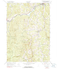
1966 Map of Woodstock South
USGS Topo · Published 1999About this map
The Ottauquechee River winds through the northern reaches of this mid-1960s landscape, connecting the village of Bridgewater to West Woodstock and the outskirts of Woodstock. This area of Windsor County is defined by its deep narrow valleys and prominent peaks like Old Baldy Mtn and Biscuit Hill. The settlement pattern reflects the traditional Vermont township structure, with small clusters at Townsend Corners and Chase Corners serving the surrounding uplands. Local infrastructure of the era is represented by the Woodstock Union High Sch and a series of historical river crossings, including both an Iron Bridge and a Covered Bridge. To the south, the terrain becomes increasingly managed by the Calvin Coolidge State Forest, while the winding course of Kedron Brook leads toward the community of South Woodstock. Family history is preserved in several burial grounds, including the Riverside Cemetery and the more remote Spear Cem.
Find a feature on this map
50 named features on this map. Tap any name to fly to it.
Don’t see what you’re looking for? This feature index may not catch every label — zoom into the map to look around manually.
Map Details
Editions of this 1966 Woodstock South Map
3 editions found
Other maps of this area

1906 · Hanover
USGS Topo · 1:62,500

1908 · Hanover
USGS Topo · 1:62,500

1911 · Woodstock
USGS Topo · 1:62,500

1913 · Woodstock
USGS Topo · 1:62,500

1926 · Claremont
USGS Topo · 1:62,500

1928 · Ludlow
USGS Topo · 1:48,000

1929 · Claremont
USGS Topo · 1:62,500

1929 · Ludlow
USGS Topo · 1:62,500

1932 · Ludlow
USGS Topo · 1:62,500

1943 · Woodstock
USGS Topo · 1:62,500