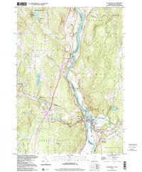
1999 Map of Woodsville
USGS Topo · Published 2000About this map
The Connecticut River serves as the focal point of this late 20th-century landscape, carving a boundary between New Hampshire and Vermont where the Ammonoosuc River and Wells River converge. This confluence defined the development of the twin villages of Woodsville and Wells River, which emerged as a significant transportation hub. The map traces the path of the Canadian Pacific railroad as it parallels the river, passing through East Ryegate and near several smaller clusters like Boltonville and Four Corners.
Find a feature on this map
54 named features on this map. Tap any name to fly to it.
Don’t see what you’re looking for? This feature index may not catch every label — zoom into the map to look around manually.
Map Details
Editions of this 1999 Woodsville Map
This is the sole edition of this map. No revisions or reprints were ever made.
Other maps of this area

1929 · Moosilauke
USGS Topo · 1:62,500

1931 · Littleton
USGS Topo · 1:62,500

1931 · Woodsville
USGS Topo · 1:48,000

1932 · Littleton
USGS Topo · 1:48,000

1932 · Moosilauke
USGS Topo · 1:62,500

1935 · Woodsville
USGS Topo · 1:62,500

1935 · Littleton
USGS Topo · 1:62,500

1938 · St. Johnsbury
USGS Topo · 1:48,000

1941 · Woodsville
USGS Topo · 1:62,500

1943 · St. Johnsbury
USGS Topo · 1:62,500