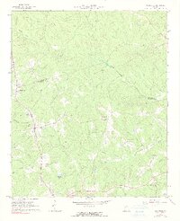
1965 Map of Woodville
USGS Topo · Published 1991About this map
The borderlands of Greene and Oglethorpe Counties are defined here by a network of rural settlements and agricultural topography as they appeared in the mid-1960s. Woodville and Bairdstown serve as primary nodes along the Georgia 77 corridor and the Georgia railroad line, while smaller communities like Durham Town and Temperance Bell appear further east. The landscape is deeply dissected by the North Fork Little River and its numerous tributaries, including Hurricane Creek and Tuggle Creek. Genealogists and local historians can locate several landmark houses of worship, such as Bairds Ch, St Pauls Ch, and Bethesda Ch. Notable landmarks like a Lookout Tower and a Radio Tower near the town center contrast with the quiet rural character of Jacksonville and the southern reaches near Stewarts Lake.
Find a feature on this map
32 named features on this map. Tap any name to fly to it.
Don’t see what you’re looking for? This feature index may not catch every label — zoom into the map to look around manually.
Map Details
Editions of this 1965 Woodville Map
2 editions found
Other maps of this area

1906 · Crawfordville
USGS Topo · 1:125,000

1953 · Athens
USGS Topo · 1:250,000

1958 · Athens
USGS Topo · 1:250,000

1959 · Athens
USGS Topo · 1:250,000

1963 · Athens
USGS Topo · 1:250,000

1965 · Woodville
USGS Topo · 1:24,000

1965 · Union Point
USGS Topo · 1:24,000

1966 · Philomath
USGS Topo · 1:24,000

1966 · Crawfordville
USGS Topo · 1:24,000

1971 · Maxeys
USGS Topo · 1:24,000