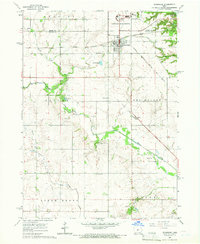
1965 Map of Woodward
USGS Topo · Published 1966About this map
Woodward State Hospital dominates the northern landscape of this mid-1960s Iowa survey, established as a significant institutional presence at the intersection of the Boone and Dallas County line. The town of Woodward serves as the regional hub, its grid defined by the Chicago Milwaukee St Paul and Pacific Railroad which cuts diagonally across the prairie. The landscape is primarily agricultural, yet marked by the early stages of large-scale water management as seen at the Saylorville Reservoir in the northeast corner.
Find a feature on this map
26 named features on this map. Tap any name to fly to it.
Don’t see what you’re looking for? This feature index may not catch every label — zoom into the map to look around manually.
Map Details
Editions of this 1965 Woodward Map
This is the sole edition of this map. No revisions or reprints were ever made.
Other maps of this area

1908 · Waukee
USGS Topo · 1:62,500

1911 · Madrid
USGS Topo · 1:62,500

1914 · Madrid
USGS Topo · 1:62,500

1949 · Adel
USGS Topo · 1:62,500

1950 · Perry
USGS Topo · 1:62,500

1951 · Perry
USGS Topo · 1:62,500

1951 · Adel
USGS Topo · 1:62,500

1954 · Omaha
USGS Topo · 1:250,000

1954 · Des Moines
USGS Topo · 1:250,000

1956 · Des Moines
USGS Topo · 1:250,000