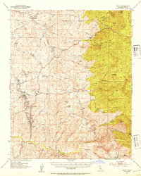
1952 Map of Woody
USGS Topo · Published 1953About this map
Granite Station and the settlement of Woody anchor this survey of the Sierra Nevada foothills in Kern County, revealing a landscape defined by ranching and early resource extraction. The topography is deeply incised by drainages such as Rag Gulch and Poso Creek, where the presence of the Round Mountain Oil Field and scattered Oil Tanks indicates the industrial footprint of the era. Genealogists will find a wealth of named homesteads, including the Villard Ranch, Carlton Ranch, and Manny Ranch, reflecting the distributed nature of local land ownership.
Find a feature on this map
66 named features on this map. Tap any name to fly to it.
Don’t see what you’re looking for? This feature index may not catch every label — zoom into the map to look around manually.
Map Details
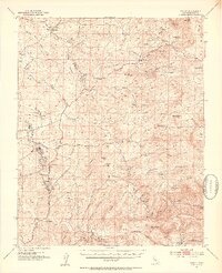
Editions of this 1952 Woody Map
2 editions found
Other maps of this area

1906 · Bakersfield
USGS Topo · 1:62,500

1910 · Buena Vista Lake
USGS Topo · 1:125,000

1912 · Buena Vista Lake
USGS Topo · 1:125,000

1914 · Caliente
USGS Topo · 1:125,000

1920 · Delonagha
USGS Topo · 1:62,500

1926 · Quincy School
USGS Topo · 1:31,680

1926 · Glennville
USGS Topo · 1:62,500

1929 · Richgrove
USGS Topo · 1:31,680

1929 · Quincy School
USGS Topo · 1:31,680

1930 · Oildale
USGS Topo · 1:31,680