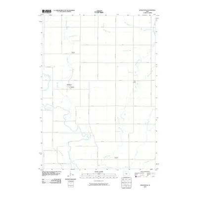
2010 Map of Woolstock
USGS Topo · Published 2010About this map
Woolstock serves as the central hub of this Wright County landscape, anchored by the Woolstock Post Office and surrounded by a highly structured grid of section roads and drainage improvements. The agricultural character of the area is defined by an extensive network of man-made waterways, including Ditch Number 172 and Ditch Number 130, which support the fertile plains between the Boone River and White Fox Creek. Genealogy researchers will find several well-placed burial grounds documenting the area's pioneer heritage, such as the Woolstock Cemetery, French Church Cemetery, and Cass Creek Cemetery. This 2010 survey illustrates the persistence of small-town Iowa infrastructure, where named creeks like Eagle Creek and Buck Creek wind through a landscape dominated by precise township engineering and rural mail routes.
Find a feature on this map
45 named features on this map. Tap any name to fly to it.
Don’t see what you’re looking for? This feature index may not catch every label — zoom into the map to look around manually.
Map Details
Editions of this 2010 Woolstock Map
This is the sole edition of this map. No revisions or reprints were ever made.
Other maps of this area

1954 · Waterloo
USGS Topo · 1:250,000

1955 · Waterloo
USGS Topo · 1:250,000

1978 · Blairsburg
USGS Topo · 1:24,000

1978 · Holmes
USGS Topo · 1:24,000

1978 · Woolstock
USGS Topo · 1:24,000

1978 · Clarion
USGS Topo · 1:24,000

1978 · Eagle Grove SW
USGS Topo · 1:24,000

1978 · Webster City
USGS Topo · 1:24,000

1978 · Clarion SW
USGS Topo · 1:24,000
1978 · Duncombe
USGS Topo · 1:24,000