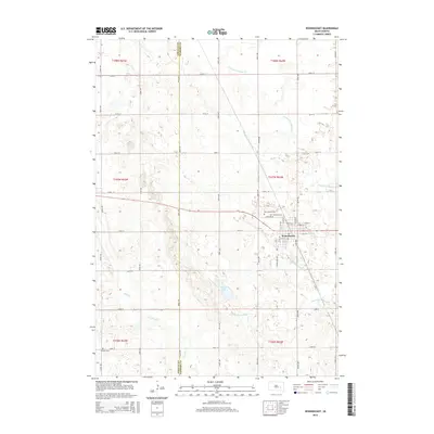
2015 Map of Woonsocket
USGS Topo · Published 2015About this map
Woonsocket serves as the central hub of this Sanborn County landscape, where the prairie grid is defined by a systematic network of drainage and seasonal watercourses. The local hydrology is managed through features like County Ditch Number 8, County Ditch Number 16, and County Ditch Number 21, which channel water across the agricultural plains toward McCoy Lake and the intermittent path of Dry Run. This 2015 survey illustrates how the landscape remains organized around its original township and range divisions, with the Jerauld Co Sanborn Co boundary marking the western edge of the quadrangle.
Find a feature on this map
31 named features on this map. Tap any name to fly to it.
Don’t see what you’re looking for? This feature index may not catch every label — zoom into the map to look around manually.
Map Details
Editions of this 2015 Woonsocket Map
This is the sole edition of this map. No revisions or reprints were ever made.
Other maps of this area

1898 · Huron
USGS Topo · 1:125,000

1899 · Mitchell
USGS Topo · 1:125,000

1953 · Huron
USGS Topo · 1:250,000

1954 · Huron
USGS Topo · 1:250,000

1955 · Mitchell
USGS Topo · 1:250,000

1958 · Forestburg NW
USGS Topo · 1:24,000

1959 · Mitchell
USGS Topo · 1:250,000

1973 · Alpena
USGS Topo · 1:24,000
1973 · Forestburg SW
USGS Topo · 1:24,000
1973 · Woonsocket
USGS Topo · 1:24,000