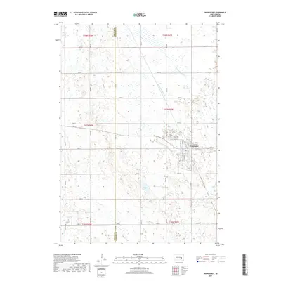
2017 Map of Woonsocket
USGS Topo · Published 2017About this map
Woonsocket sits as the central hub of this prairie landscape on the border of Jerauld and Sanborn counties. The town's grid is well-defined, bordered by local landmarks like Saint Wilfrid Cem and Eventide Cem on its western edge. This 2017 survey reveals a highly managed hydrologic system, where the natural flow of Dry Run and the waters of McCoy Lake are integrated into an extensive network of drainage infrastructure, including County Ditch Number 8, County Ditch Number 16, and County Ditch Number 21. This engineering reflects the region's agricultural adaptation, ensuring the viability of the surrounding plains. To the southwest, the more isolated Feistner Cem serves as a quiet marker of the area's rural genealogy and early settlement patterns along the section lines.
Find a feature on this map
47 named features on this map. Tap any name to fly to it.
Don’t see what you’re looking for? This feature index may not catch every label — zoom into the map to look around manually.
Map Details
Editions of this 2017 Woonsocket Map
This is the sole edition of this map. No revisions or reprints were ever made.
Other maps of this area

1898 · Huron
USGS Topo · 1:125,000

1899 · Mitchell
USGS Topo · 1:125,000

1953 · Huron
USGS Topo · 1:250,000

1954 · Huron
USGS Topo · 1:250,000

1955 · Mitchell
USGS Topo · 1:250,000

1958 · Forestburg NW
USGS Topo · 1:24,000

1959 · Mitchell
USGS Topo · 1:250,000

1973 · Alpena
USGS Topo · 1:24,000
1973 · Forestburg SW
USGS Topo · 1:24,000
1973 · Woonsocket
USGS Topo · 1:24,000