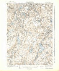
1939 Map of Worcester South
USGS Topo · Published 1939About this map
Holy Cross College stands at the northern edge of this late 1930s landscape, overlookng the dense rail and industrial corridor of the Blackstone River. This era shows the intricate network of the Boston and Albany RR and New Haven RR supporting local hubs like Auburn Sta. The map reveals a high concentration of ethnic and religious memorial sites, such as the New Swedish Cem, St Johns Cemetery, and B'nai Brith Cem, reflecting the diverse immigrant heritage that shaped the region's mid-century identity. Beyond the urban fringe of Worcester, the geography transitions to a series of water-powered mill villages and reservoirs, including Stoneville and Bramanville. The presence of the Worcester Sewage Disposal Plant and numerous local schools like the Julia Bancroft Sch indicates the infrastructure and civic growth of the pre-war period.
Find a feature on this map
82 named features on this map. Tap any name to fly to it.
Don’t see what you’re looking for? This feature index may not catch every label — zoom into the map to look around manually.
Map Details
Editions of this 1939 Worcester South Map
4 editions found
Other maps of this area

1885 · Worcester
USGS Topo · 1:62,500

1886 · Worcester
USGS Topo · 1:62,500

1886 · Blackstone
USGS Topo · 1:62,500

1887 · Marlboro
USGS Topo · 1:62,500

1889 · Marlboro
USGS Topo · 1:62,500

1889 · Blackstone
USGS Topo · 1:62,500

1889 · Webster
USGS Topo · 1:62,500

1892 · Webster
USGS Topo · 1:62,500

1892 · Worcester
USGS Topo · 1:62,500

1893 · Blackstone
USGS Topo · 1:62,500