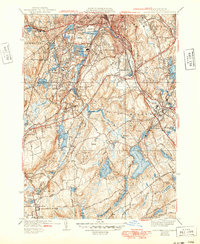
1939 Map of Worcester South
USGS Topo · Published 1949About this map
The industrial and academic landscape of Worcester and its southern suburbs comes into focus during the late 1930s, anchored by the hilltop campus of Holy Cross College. The region is defined by a dense network of water systems, from the Blackstone River to massive industrial reservoirs like the Stoneville Reservoir and Leesville Pond. Transportation corridors of the New York New Haven and Hartford RR and the Boston and Albany RR carve through the valley, serving established mill settlements such as Jamesville, Stoneville, and Bramanville. The transition toward mid-century aviation is evident with both Auburn Airport and Windle Airport appearing on the landscape. Local civic life is well-documented through named schools like the Julia Bancroft Sch and the Calvin Coolidge Sch, alongside extensive burial grounds including Hope Cemetery and St Johns Cemetery.
Find a feature on this map
100 named features on this map. Tap any name to fly to it.
Don’t see what you’re looking for? This feature index may not catch every label — zoom into the map to look around manually.
Map Details
Editions of this 1939 Worcester South Map
4 editions found
Other maps of this area

1885 · Worcester
USGS Topo · 1:62,500

1886 · Worcester
USGS Topo · 1:62,500

1886 · Blackstone
USGS Topo · 1:62,500

1887 · Marlboro
USGS Topo · 1:62,500

1889 · Marlboro
USGS Topo · 1:62,500

1889 · Blackstone
USGS Topo · 1:62,500

1889 · Webster
USGS Topo · 1:62,500

1892 · Webster
USGS Topo · 1:62,500

1892 · Worcester
USGS Topo · 1:62,500

1893 · Blackstone
USGS Topo · 1:62,500