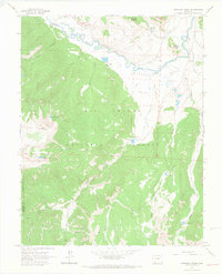
1964 Map of Workman Creek
USGS Topo · Published 1967About this map
Rio Grande waters curve through the northern reaches of this high-altitude landscape, where the flat expanse of Antelope Park meets the steep, timbered slopes of the Rio Grande National Forest. The map documents a rugged interior navigated by a network of specialized routes, including a Stock Driveway for moving livestock and various Jeep Trails and Pack Trails that provided access to high mountain basins. High-country landmarks like Baldy Mountain and Ruby Mountain overlook a series of alpine waters, including Love Lake, Jumper Lake, and Baldy Lake. Evidence of earlier industrial efforts is visible at the Solomon Tunnel and a Gravel Pit near the river. The terrain is divided by the Hinsdale and Mineral county line, marking a boundary through a region defined by tributary systems such as Trout Creek and its many branches.
Find a feature on this map
33 named features on this map. Tap any name to fly to it.
Don’t see what you’re looking for? This feature index may not catch every label — zoom into the map to look around manually.
Map Details
Editions of this 1964 Workman Creek Map
3 editions found
Other maps of this area

1905 · San Cristobal
USGS Topo · 1:125,000

1907 · San Cristobal
USGS Topo · 1:125,000

1914 · Creede
USGS Topo · 1:125,000

1916 · Creede
USGS Topo · 1:125,000

1945 · Durango
USGS Topo · 1:250,000

1953 · Durango
USGS Topo · 1:250,000

1954 · Durango
USGS Topo · 1:250,000

1957 · Spar City
USGS Topo · 1:62,500

1959 · Creede
USGS Topo · 1:62,500

1959 · Bristol Head
USGS Topo · 1:62,500