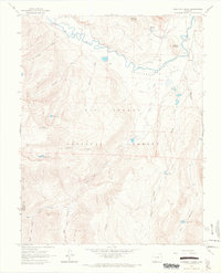
1964 Map of Workman Creek
USGS Topo · Published 1967About this map
The Rio Grande meanders through the high country of Rio Grande National Forest in this mid-1960s study, carving through the expansive Antelope Park. The landscape is defined by its seasonal use and water resources, evidenced by the Stock Driveway winding along Long Ridge and the Park Corral located near the riverbank. High-altitude peaks such as Ruby Mountain and Baldy Mountain overlook a network of tributary streams including Workman Creek and Trout Creek.
Find a feature on this map
38 named features on this map. Tap any name to fly to it.
Don’t see what you’re looking for? This feature index may not catch every label — zoom into the map to look around manually.
Map Details
Editions of this 1964 Workman Creek Map
3 editions found
Other maps of this area

1905 · San Cristobal
USGS Topo · 1:125,000

1907 · San Cristobal
USGS Topo · 1:125,000

1914 · Creede
USGS Topo · 1:125,000

1916 · Creede
USGS Topo · 1:125,000

1945 · Durango
USGS Topo · 1:250,000

1953 · Durango
USGS Topo · 1:250,000

1954 · Durango
USGS Topo · 1:250,000

1957 · Spar City
USGS Topo · 1:62,500

1959 · Creede
USGS Topo · 1:62,500

1959 · Bristol Head
USGS Topo · 1:62,500