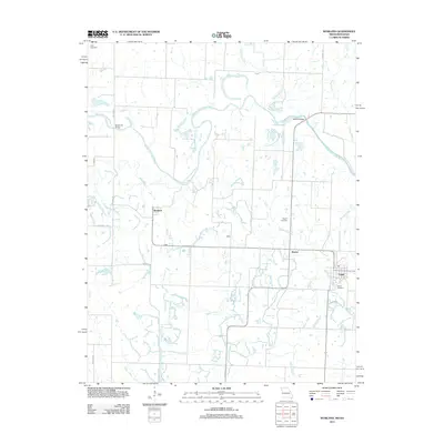
2011 Map of Worland
USGS Topo · Published 2011About this map
The Marais des Cygnes River meanders across the borderlands of Missouri and Kansas, defining the hydrologic character of this rural landscape. This modern survey illustrates the persistent agricultural and riparian patterns of the region, where small settlements like Worland and Foster are linked by a network of county roads. The river’s path is punctuated by the State Line Bridge and Marble Bridge, key crossing points that have historically facilitated movement between the two states. Several named rural cemeteries, including Hays Cemetery in the north and Salem Cemetery near Foster, offer specific points of interest for genealogists tracing long-established families in the area. The terrain is further etched by numerous tributaries such as Mine Creek, Walnut Creek, and Gillum Creek, which drain the lowlands and influence the layout of small crossroads communities like Tiger, Ward, and Rucker.
Find a feature on this map
23 named features on this map. Tap any name to fly to it.
Don’t see what you’re looking for? This feature index may not catch every label — zoom into the map to look around manually.
Map Details
Editions of this 2011 Worland Map
This is the sole edition of this map. No revisions or reprints were ever made.
Other maps of this area

1887 · Butler
USGS Topo · 1:125,000

1887 · Mound City
USGS Topo · 1:125,000

1893 · Mound City
USGS Topo · 1:125,000

1894 · Butler
USGS Topo · 1:125,000

1937 · New Home
USGS Topo · 1:24,000

1938 · Worland
USGS Topo · 1:24,000

1940 · Worland
USGS Topo · 1:24,000

1940 · Hume
USGS Topo · 1:24,000

1942 · Hume
USGS Topo · 1:24,000
1942 · Sprague
USGS Topo · 1:24,000