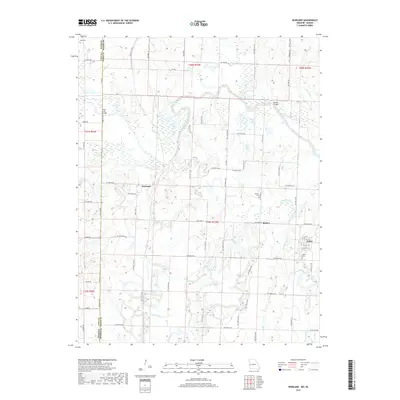
2017 Map of Worland
USGS Topo · Published 2017About this map
The Marais des Cygnes River winds across the border of Kansas and Missouri, defining the landscape of this western Bates County region. The settlement of Worland sits near the state line, while Foster is situated to the southeast, showing a concentrated grid of streets including 6th St and 11th St. This area is marked by several historical burial grounds, such as Salem Cem south of Foster and Woofin Cem near State Hwy V. The drainage network is dense with numerous tributaries including Walnut Cr, Gillum Cr, and Cottonwood Cr, which feed the river system. Local transit is supported by a mix of state routes and county roads like NW 1002 Rd and State Hwy U, which connect the small communities and rural farmsteads in the T39N-R33W and T40N R33W sections.
Find a feature on this map
72 named features on this map. Tap any name to fly to it.
Don’t see what you’re looking for? This feature index may not catch every label — zoom into the map to look around manually.
Map Details
Editions of this 2017 Worland Map
This is the sole edition of this map. No revisions or reprints were ever made.
Other maps of this area

1887 · Butler
USGS Topo · 1:125,000

1887 · Mound City
USGS Topo · 1:125,000

1893 · Mound City
USGS Topo · 1:125,000

1894 · Butler
USGS Topo · 1:125,000

1937 · New Home
USGS Topo · 1:24,000

1938 · Worland
USGS Topo · 1:24,000

1940 · Worland
USGS Topo · 1:24,000

1940 · Hume
USGS Topo · 1:24,000

1942 · Hume
USGS Topo · 1:24,000
1942 · Sprague
USGS Topo · 1:24,000