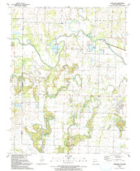
1991 Map of Worland
USGS Topo · Published 1991About this map
The Marias Des Cygnes River meanders across this borderland between Missouri and Kansas, defined by an extensive system of Levee fortifications protecting the surrounding bottomlands. The landscape reflects a legacy of extraction and transit, where an Old Railroad Grade cuts through the terrain near Worland and Tiger. Industrial activity is evident in the presence of a Strip Mine, Mine, and a Gravel Pit, signaling the region's reliance on geological resources during the late twentieth century.
Find a feature on this map
26 named features on this map. Tap any name to fly to it.
Don’t see what you’re looking for? This feature index may not catch every label — zoom into the map to look around manually.
Map Details
Editions of this 1991 Worland Map
This is the sole edition of this map. No revisions or reprints were ever made.
Other maps of this area

1887 · Butler
USGS Topo · 1:125,000

1887 · Mound City
USGS Topo · 1:125,000

1893 · Mound City
USGS Topo · 1:125,000

1894 · Butler
USGS Topo · 1:125,000

1937 · New Home
USGS Topo · 1:24,000

1938 · Worland
USGS Topo · 1:24,000

1940 · Worland
USGS Topo · 1:24,000

1940 · Hume
USGS Topo · 1:24,000

1942 · Hume
USGS Topo · 1:24,000
1942 · Sprague
USGS Topo · 1:24,000