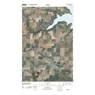
2010 Map of Worley
USGS Topo · Published 2010About this map
The town of Worley serves as the primary hub in this Kootenai County landscape, situated where local roads converge near the southern edge of the survey. The map reveals a significant cultural and genealogical concentration north of the town center, featuring the Coeur d'Alene Indian Cemetery, Saint Michaels Cemetery, and Worley Cemetery clustered together. This proximity of sacred sites reflects the deeply rooted history of the local community. To the north, the geography shifts toward the aquatic reaches of Harrison Slough and the prominent points of Rockford Point and Mi o'lmkhw Point. The terrain is defined by the winding course of North Fork Rock Creek and elevations like Worley Mountain. Notable landmarks including Camp Four Echoes and the Alexander McDowell Rest Area punctuate the landscape, while smaller settlements like Mozart and Amwaco are connected by a network of rural routes such as S Cave Bay Rd and W Bitter Rd.
Find a feature on this map
42 named features on this map. Tap any name to fly to it.
Don’t see what you’re looking for? This feature index may not catch every label — zoom into the map to look around manually.
Map Details
Editions of this 2010 Worley Map
This is the sole edition of this map. No revisions or reprints were ever made.
Other maps of this area

1901 · Spokane
USGS Topo · 1:125,000

1903 · Oakesdale
USGS Topo · 1:125,000

1903 · Rathdrum
USGS Topo · 1:125,000

1905 · Oakesdale
USGS Topo · 1:125,000

1949 · Greenacres
USGS Topo · 1:62,500

1951 · Greenacres
USGS Topo · 1:62,500

1954 · Fairfield
USGS Topo · 1:62,500

1955 · Spokane
USGS Topo · 1:250,000

1957 · Plummer
USGS Topo · 1:62,500

1957 · Coeur D'Alene
USGS Topo · 1:62,500